Name the country that lost one whole day in 2011

Hello! It’s Ceren from Datawrapper’s customer support and success team, reporting for duty, and in this week’s Weekly Chart, I’m about to give you the answer to a geopolitical trivia question that you can impress your mates with.
Okay, the country didn't really lose a day. People woke up, went to work and school, and ran their daily errands as they normally would, but overnight, their calendars skipped ahead.
At the end of December 29, 2011, Samoa moved time zones. The goal was to align itself with key business partners, such as Australia and New Zealand, two countries that are also home to a large Samoan diaspora population. Because the country sits right next to the International Date Line — and jumped from UTC−11:00 to UTC+13:00 — what would have been a small shift anywhere else translated to a full-day difference in Samoa. When the clocks struck midnight at the end of December 29, 2011, people in Samoa flipped their calendars to December 31, losing one whole day in the process. A relatively small sacrifice, given the long-term business benefits and the bonus of being able to mark important events, such as birthdays and religious holidays, on the same day as family overseas.
American Samoa, on the other hand, stays to the east side of the International Date Line, which leaves the two neighboring regions with a 24-hour calendar difference. As one calendar day finishes in Samoa, the same one only begins in American Samoa. You could take a short flight and celebrate your birthday all over again.
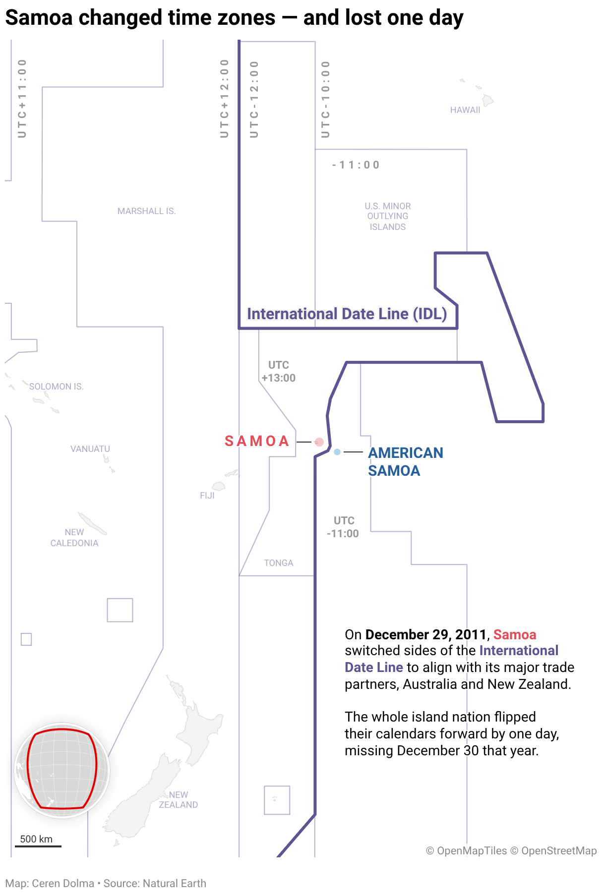
This is neither the first nor the only time a change like this has happened. Samoa moved in the opposite direction 119 years earlier to align itself with then-major trade partners, such as the United States and Europe. The International Date Line has been altered several times in the past, including shifts around the Philippines, Alaska, Kiribati, and more.
The lines that shape our time
The International Date Line is one of the two geographic lines that play a key role in how we conceptualize time around the world. This imaginary, far-from-straight line runs north to south, roughly following the 180° line of longitude, and it is the counterpart of the Greenwich Prime Meridian, at 0°, on the other side of the globe.
Greenwich was selected as the Prime Meridian in 1884, at the International Meridian Conference in Washington, D.C., to establish a shared reference point for coordinating rail and sea navigation across borders. It was selected over three other candidates — Paris, Berlin, and the host, Washington, D.C. — largely because Greenwich time was already commonly used worldwide, as a result of British colonial rule.
The Greenwich Prime Meridian is the basis of Greenwich Mean Time (GMT), the reference against which all other time zones were set. Today, that role belongs to Coordinated Universal Time (UTC), which, for everyday purposes, matches GMT.
The IDL exists to reconcile a peculiar problem. If you were to sail around the world, the rule is that for every 15° of longitude crossed east of Greenwich, clocks should be set an hour forward. For every 15° of longitude westward, they should be set back by an hour. This means that if you’ve travelled to 180° of longitude from the Prime Meridian, your clock will show a different time, based on your direction of travel. The IDL resolves this as travellers crossing the line change their clocks by 24 hours — backward if travelling eastward and forward if travelling westward.
Of course, this is all well and good at sea, where the longitudinal change can be the main parameter, but on land it gets a lot more complicated.
Time zone lines are wonky, for good reasons
If you have travelled or tried to contact someone far enough, you’re probably familiar with time zones and their acronyms, such as EST, WAT, and CET. Most of them are set at a fixed difference from UTC, with some shifting seasonally for daylight saving time. Similar to the IDL, the lines delineating these time zones are far from straight. While they still are informed by lines of longitude, their exact placement isn’t decided by geography alone. Each country gets to decide which time zone it will follow and whether it will observe daylight saving time.

Economic and political interests are other key factors that can influence a country’s choice of time zone. In 1940, Franco moved Spain's clocks forward by an hour to align with Nazi Germany during World War II, and Spain has remained in CET (Central European Time) ever since. While a one-hour difference may seem far less significant than a change over the IDL, Spain’s time shift actually placed it in what some call the geographically “wrong” time zone. Some economists even argue this mismatch contributes to the country’s long work days and famously late mealtimes.
China is the largest country in the world to use a single time zone, but that wasn’t always the case. The country spans more than 60 degrees of longitude and could have five different time zones. In 1949, it unified its time zones and has since then used China Standard Time (CST), locally known as Beijing time, set to UTC+08:00. In a country of this scale, the impacts are significant. In western provinces such as Xinjiang, the primary home to China's Uyghur minority, the sun rises and sets much later than in the eastern coastal regions. While a single time zone undoubtedly has practical and economic benefits, some see it as a means to “consolidate and legitimize power.”
Time zones can cause a lot of chaos and complexity — as someone who has miscalculated differences one too many times, I know — and many have considered abolishing them altogether. Well-developed alternatives already exist: the Hanke–Henry Permanent Calendar, for example, rethinks time in several ways. I’m not sure it would help with the underlying political and economic complexities, and it is hard to imagine time conceptualized in a completely different way. But from a selfish perspective, it would be nice never to have to convert time zones in my head again.
Thanks for taking the time! Come back next week to hear from Alicia from our design team.


